Location: Northwestern Washington
Designated: 1995
Total Size: 5.5 million acres
Acreage under vine: 121 acres (49 hectares)
Top Varieties: Pinot Noir, Madeline Angevine, Siegerrebe
Soils: Gravelly sandy loam over glacial hardpan
Average Annual Precipitation: 15-60 inches
Two Things to Know:
- Currently Washington’s only growing region located west of the Cascade Mountain range.
- It therefore has a radically different climate and grows very different varieties.
Puget Sound is located in north-western Washington. It is one of Washington’s few appellations located outside the Columbia Valley.
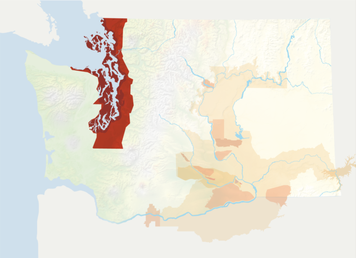
Named after the body of water that stretches across the region, Puget Sound has the distinction of being Washington’s only growing region located west of the Cascade Mountains. It encompasses a wide swath of land—including numerous islands—from the Canadian border to the north through Seattle to Olympia, the state’s capitol to the south.
Due to its location, Puget Sound is unique for Washington as a growing region in that it has a temperate, maritime climate. In contrast, Washington’s growing regions east of the Cascade crest have arid or semi-arid, continental climates. Puget Sound is therefore by far Washington’s coolest and wettest growing region.
Rainfall ranges from 15 inches to 60 inches annually, with most precipitation occurring from November through April. In contrast, summers are typically fairly warm and dry. The abundant rainfall means that most vineyards in this area can dry farm, in contrast to eastern Washington where irrigation is required due to the desert climate.
Cool climate grapes dominate in this area, with Pinot Noir the most planted variety followed by Riesling. However, the area also has plantings of Madeleine Angevine, Müller-Thurgau, Regent, Siegerrebe, and other varieties not seen elsewhere in the state.